Oahu Sites

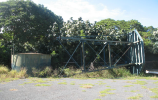
Lanikuhonua Water Tower / Kapolei

Address Olani Street and Aliinui Drive, Kapolei, Hawaii 96734 TMK No TMK SHPD Historic Site Number 50-80-12-8158 Abstract The Lanikuhonua water tower is significant on the local level under criterion C as an example of a metal lattice tower, which is typical of its period in its design, materials, workmanship and methods of construction.  The water tower is the only tangible structure to remain from Kamokila Campbell's homesite, as her house and the cottage which stood on the grounds are no longer extant.  The tower stored water obtained from artesian wells and provided water pressure to operate running water in the house and on the grounds.  The water tower continued in operation until the early 1960s, when it was supplanted by the City and County's city water system. This list of Hawaii’s historic properties is provided as a public service by Historic Hawaii Foundation. It is not the official list of properties designated on the Hawaii State Register of Historic Places. For official designations and determinations of eligibility, contact the State Historic Preservation Division of the Department of Land and Natural Resources of the State of Hawaii at 808-692-8015.

2018-08-01T16:27:34-10:00May 17th, 2018|Categories: Historic Properties|Tags: |

Piliaama Stone (2016)

Photos: Courtesy of Ian Masterson Article Written By: Katrina Valcourt What is it? In Hawaiian lore, Piliaama was a konohiki, surfer and fisherman on the North Shore, until one day, when he was running away form an alii women who was in love with him, he vanishedm leaving nothing but his footprint in a large rock, about 3 feet tall and 4 feet wide, near Waimea Bay. Ian Masterson, noted surfer and WCC professor, says he discovered the stone after delving into Waimea's surfing history and reading Gilbert McAllister's description of it in Archaeology of Oahu (1933). He believes the stone should be honored as a scared site, perhaps as a place for offerings to the patron surfer of the bay. What threatens it? The Piliaama Stone sits very close to the road, only a few feet back form the asphalt. It is in danger of being hit by cars of nicked by tree-trimming equipment, which has already left marks on the front of it. If nobody knows it's there, Piliaama's story may be lost. What can be done? "How do we deal with sacred sites, do we leave them hidden or do we honor them? It feels like Piliaama should be honored," Masterson says. He suggests putting a sign  and short wrought-iron fence around it, like the Kahuna Stones in Waikiki, or even a small chain encircling the stone. But building a protective barrier may be a safety issue so close to Kamehameha Highway. Anyone who wants to take on this project would need to discuss it with the State Historic Preservation Division first. "For me, it would be great to be able to be a caretaker, remove brushes away from that area and clean the [...]

2016-11-17T10:23:57-10:00November 17th, 2016|Categories: MES Oahu|Tags: , , |

Ewa Plain Battlefield

Address Roosevelt and Essex Road, Kalaeloa, HI 96707 TMK (1) 9-1-013, 096, 099, 043 (portions) SHPD Historic Site Number Abstract The attacks on Oahu on December 7, 1941, precipitated the entry of the United States into World War II. The Ewa Plain Battlefield appears to have been attacked just before the attack on Pearl Harbor itself.  Imperial Japanese Navy submarines continued to threaten the area until December 31. Ewa Field served as the forward Marine Corps airfield in the Hawaiian Islands during World War II and became known to Marine aviators as their "Crossroads of the Pacific." This list of Hawaii’s historic properties is provided as a public service by Historic Hawaii Foundation. It is not the official list of properties designated on the Hawaii State Register of Historic Places. For official designations and determinations of eligibility, contact the State Historic Preservation Division of the Department of Land and Natural Resources of the State of Hawaii at 808-692-8015.

2017-04-21T01:01:07-10:00March 23rd, 2016|Categories: Historic Properties|Tags: |

Puowaina (National Memorial Cemetery of the Pacific)

Address 2177 Puowaina Drive, Honolulu, HI 96813 TMK (1) 2-2-005:001, :002 SHPD Historic Site Number 80-14-1300 Abstract Puowaina is a volcanic crater approximately oval in shape, the rim rises 461 feet above sea level affording a view of Diamond Head, Pearl Harbor, and the city of Honolulu. The use of careful landscaping and flat grave markers has been enhanced by the impressive memorial erected by the American Battle Monuments Commission. As a site of pre-historic significance, Puowaina, has a deep religious meaning for the Hawaiian people long before Western contact with the islands in 1778. Puowaina means "Hill of Sacrifice" and this is where offenders of certain "kapu" were taken to be sacrificed. On January 4, 1949, the Punchbowl crater was established as the National Memorial Cemetery of the Pacific when an unknown serviceman, killed in the attack on Pearl Harbor, was the first American was buried there. The National Memorial Cemetery of the Pacific is a final resting place for those whose sacrifices have preserved America's freedoms. This list of Hawaii’s historic properties is provided as a public service by Historic Hawaii Foundation. It is not the official list of properties designated on the Hawaii State Register of Historic Places. For official designations and determinations of eligibility, contact the State Historic Preservation Division of the Department of Land and Natural Resources of the State of Hawaii at 808-692-8015.

2022-11-22T16:02:06-10:00February 19th, 2014|Categories: Historic Properties|Tags: , |

Mother Waldron Playground

Address Cooke Street and Halekauwila Street, Honolulu, HI 96813 TMK (1) 2-1-051:005 SHPD Historic Site Number 80-14-1388 Abstract Mother Waldron Park is a 1.76 acre parcel bounded by Coral, Halekauwila and Pohukaina Streets and Lana Lane and was constructed in 1937. The focal point of the playground is the comfort station pavilion, which stands in the middle of the park on the Diamond Head side. The playground layout is symmetrical, with the axis of the pavilion and Coral Street entry dividing the park in two. The playground was divided into one section for the younger children and another for the older. Mother Waldron Park is significant for its association with the playground movement. It is also significant for its associations with the earlier work of Margaret Waldron in the Kakaako district. This list of Hawaii’s historic properties is provided as a public service by Historic Hawaii Foundation. It is not the official list of properties designated on the Hawaii State Register of Historic Places. For official designations and determinations of eligibility, contact the State Historic Preservation Division of the Department of Land and Natural Resources of the State of Hawaii at 808-692-8015.

2022-11-22T16:02:40-10:00February 19th, 2014|Categories: Historic Properties|Tags: |

Kawananakoa Playground

Address Nuuanu Avenue and South Kuakini Street Honolulu, HI 96813 TMK (1) 2-2-009:011 (portion), :012 SHPD Historic Site Number 80-14-1388 Abstract Kawananakoa Playground is a 2.4 acre parcel situated at the lower end of Nuuanu Valley in a highly populated residential district and was constructed in 1937. A poured concrete perimeter wall, approximately three feet high, encircles the playground on the side streets. Kawananakoa Playground is significant for its associations with the development of parks in the City and County of Honolulu in the 1930s and the playground movement. In addition, the park is significant architecturally as its design is typical of the period and reflects the work of Harry Sims Bent, of the more prominent architects practicing in Honolulu at the time. This list of Hawaii’s historic properties is provided as a public service by Historic Hawaii Foundation. It is not the official list of properties designated on the Hawaii State Register of Historic Places. For official designations and determinations of eligibility, contact the State Historic Preservation Division of the Department of Land and Natural Resources of the State of Hawaii at 808-692-8015.

2017-04-21T01:02:46-10:00February 19th, 2014|Categories: Historic Properties|Tags: |

Uluhaimalama

Address 352 Auwaiolimu Street, Honolulu, HI 96813 TMK (1) 2-2-014:005, :006 SHPD Historic Site Number 80-14-9042 Abstract Uluhaimalama is now set in an urban neighborhood composed of medium to high density single family and multi-unit housing. The cemetery is located on the lots that once served as the Royal Flower Garden of Queen Liliuokalani. The lots have remarkably remained intact more than 100 years after the function of the garden was changed to a cemetery. Uluhaimalama is significant in Hawaiian and United States history as a garden-cemetery for its associations relating to the overthrow of the Hawaiian Kingdom in 1893 and for its association with, its former owner, Queen Liliuokalani. Uluhaimalama was one source of flowers delivered to the Queen during her imprisonment at Iolani Palace and her confinement at her home Washington Place after the government of the Hawaiian Kingdom was seized. This list of Hawaii’s historic properties is provided as a public service by Historic Hawaii Foundation. It is not the official list of properties designated on the Hawaii State Register of Historic Places. For official designations and determinations of eligibility, contact the State Historic Preservation Division of the Department of Land and Natural Resources of the State of Hawaii at 808-692-8015.

2017-04-21T01:02:46-10:00February 19th, 2014|Categories: Historic Properties|Tags: |

Ala Moana Park

Address 1201 Ala Moana Boulevard, Honolulu, HI 96813 TMK (1) 2-3-037:001 SHPD Historic Site Number 80-14-1388 Abstract Constructed in 1934, Ala Moana Park is a 76-acre beach park featuring a mile-long white sand beach, an offshore coral reef, and lawns dotted by palms, banyans and flowering tropical trees. The largest structure within the park is the sports pavilion. The pavilion is an open structure with a gable roofed and features with two wall-sized murals by Robert Lee Eskridge depicting the Hawaiian makahiki. The Ala Moana Park is significant for its association with the development of parks in the City and County of Honolulu in the 1930s. In addition, the park is significant architecturally as its design is typical of the period and reflects the work of Harry Sims Bent, one of the more prominent architects practicing in Honolulu at the time. This list of Hawaii’s historic properties is provided as a public service by Historic Hawaii Foundation. It is not the official list of properties designated on the Hawaii State Register of Historic Places. For official designations and determinations of eligibility, contact the State Historic Preservation Division of the Department of Land and Natural Resources of the State of Hawaii at 808-692-8015.

2017-04-21T01:02:46-10:00February 19th, 2014|Categories: Historic Properties|Tags: |

Kyoto Gardens of Honolulu Memorial Park

Address 22 Craigside Place, Honolulu, HI 96817 TMK (1) 2-2-020:001 SHPD Historic Site Number 80-14-9848 National Register of Historic Places #04000020 Abstract The Kyoto Gardens is a portion of the Honolulu Memorial Park cemetery with two large columbarium structures and a Japanese garden at the eastern half of the Honolulu Memorial Park. The three-tiered Pagoda, the Kinkaku-ji Temple, and the Mirror Gardens located within the Honolulu Memorial Park are significant for being among the best examples of Japanese traditional-style structures and gardens built outside of Japan. The Pagoda is one of three known inhabitable pagodas in the United States, and it is the largest of the three. This list of Hawaii’s historic properties is provided as a public service by Historic Hawaii Foundation. It is not the official list of properties designated on the Hawaii State Register of Historic Places. For official designations and determinations of eligibility, contact the State Historic Preservation Division of the Department of Land and Natural Resources of the State of Hawaii at 808-692-8015.

2017-04-21T01:02:46-10:00February 19th, 2014|Categories: Historic Properties|Tags: , |

Thomas Square

Address 102 Victoria Street, Honolulu, HI 96813 TMK (1) 2-4-001:001 SHPD Historic Site Number 80-14-9990 National Register of Historic Places #72000423 Abstract This approximately 6.5 acre public park, which was constructed in 1843, is surrounded by a trimmed mock orange hedge and contains: a large cascading fountain; a number of banyan, flowering shower, and Hawaiian "fish poison" trees; a pedestrian sidewalk; and an expansive lawn area. Thomas Square is significant for its association with the nineteenth century political history of the Kingdom of Hawaii. This list of Hawaii’s historic properties is provided as a public service by Historic Hawaii Foundation. It is not the official list of properties designated on the Hawaii State Register of Historic Places. For official designations and determinations of eligibility, contact the State Historic Preservation Division of the Department of Land and Natural Resources of the State of Hawaii at 808-692-8015.

2017-04-21T01:02:47-10:00February 19th, 2014|Categories: Historic Properties|Tags: , |
Go to Top