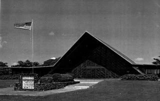
Pearl Harbor Memorial Community Church
Address 20 Bougainville Drive Honolulu, HI 96819 TMK (1) 1-1-010:034 (por.) SHPD Historic Site Number 80-14-9847 Abstract The Pearl Harbor Memorial Community Church, built in 1957, features a distinctive A-frame structure utilizing glu-lam beams with large concrete footings that house the sanctuary. The relatively gentle slope of the frame makes the building appear to rise from the earth. The use of lava rock walls that fill in the lower parts of the A-frame aid in this illusion. The church is primarily significant for its high artistic value, with its large Memorial stained-glass window, which may be one of two large stained-glass windows done in Hawaii by John Wallis. It is also an exemplary example of the utilization of A-frame technology in Hawaii. This list of Hawaii’s historic properties is provided as a public service by Historic Hawaii Foundation. It is not the official list of properties designated on the Hawaii State Register of Historic Places. For official designations and determinations of eligibility, contact the State Historic Preservation Division of the Department of Land and Natural Resources of the State of Hawaii at 808-692-8015.