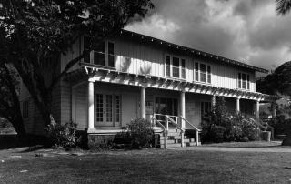
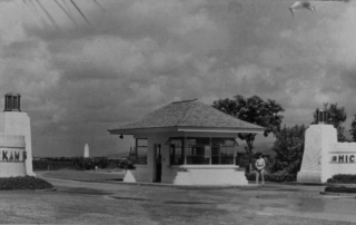
Historic Properties

Menehune Fishpond (Alekoko Fishpond)

Address Hule‘ia River, Lihue, Hawaii TMK N/A SHPD Historic Site Number N/A National Register of Historic Places #73000677 Download the National Register Nomination Form Abstract The Menehune Fishpond, also called Alekoko or Niamalu Pond, lies at a large bend in the Hule‘ia River, from which it is separated by a wall 900 yards long. It is the best example of an inland fishpond in the entire state, and is said to have been built by Menehune, suggesting that it was built during the earliest period of Hawaiian settlement. This list of Hawaii’s historic properties is provided as a public service by Historic Hawaii Foundation. It is not the official list of properties designated on the Hawaii State Register of Historic Places. For official designations and determinations of eligibility, contact the State Historic Preservation Division of the Department of Land and Natural Resources of the State of Hawaii at 808-692-8015.

2024-01-23T15:33:20-10:00June 20th, 2014|Categories: Historic Properties|Tags: , |

Camp Sloggett

Address Kokee State Park, 3600 Kokee Road, Kekaha, Kauai 96796 TMK N/A SHPD Historic Site Number N/A National Register of Historic Places #93000773 Abstract Camp Sloggett is significant as a surviving example of camp architecture from the early 1920s and for its associations with the Sloggett family and the YWCA. This list of Hawaii’s historic properties is provided as a public service by Historic Hawaii Foundation. It is not the official list of properties designated on the Hawaii State Register of Historic Places. For official designations and determinations of eligibility, contact the State Historic Preservation Division of the Department of Land and Natural Resources of the State of Hawaii at 808-692-8015.

2017-04-21T01:01:37-10:00June 16th, 2014|Categories: Historic Properties|Tags: , |

Kikiaola (Menehune Ditch)

Address Menehune Rd., Waimea, Hawaii 96796 TMK N/A SHPD Historic Site Number 30-09-26 National Register of Historic Places #84000270 Abstract Kīkīaola is a historic irrigation ditch (‘auwai) said to have been built by Menehune, suggesting that it was built during the earliest period of Hawaiian settlement. Hawaiians built many stone-lined ‘auwai to irrigate ponds for growing taro, but very rarely used dressed stone to line the ditches. The finely cut basalt blocks that line sections of the outer wall of the Menehune Ditch make it quite exceptional. This list of Hawaii’s historic properties is provided as a public service by Historic Hawaii Foundation. It is not the official list of properties designated on the Hawaii State Register of Historic Places. For official designations and determinations of eligibility, contact the State Historic Preservation Division of the Department of Land and Natural Resources of the State of Hawaii at 808-692-8015.

2017-04-21T01:01:37-10:00June 16th, 2014|Categories: Historic Properties|Tags: , |

Kong Lung Store

Address 2484 Keneke Street (Lighthouse Road), Kilauea, Kauai 96754 TMK (4) 5-2-008:029 SHPD Historic Site Number 30-04-9394 National Register of Historic Places #93000776 Abstract The Kong Lung Store is a single-story Craftsman/bungalow-style structure of fieldstone up to the lower portion of the gable. It is the last of the stone structures built by the Kilauea Sugar Company and was constructed ca. 1941 to replace an older wooden frame building at the same site. The store is an example of how the masonry construction used for domestic architecture in Kilauea was adapted to a commercial building. It is also significant for its associations with the sugar plantation and the goods it provided for the plantation workers. While the building was owned by the plantation, it was managed independently by Chew Lung. This list of Hawaii’s historic properties is provided as a public service by Historic Hawaii Foundation. It is not the official list of properties designated on the Hawaii State Register of Historic Places. For official designations and determinations of eligibility, contact the State Historic Preservation Division of the Department of Land and Natural Resources of the State of Hawaii at 808-692-8015.

2017-04-21T01:01:37-10:00June 9th, 2014|Categories: Historic Properties|Tags: , |

Kaimuki: A Brief History

Address Honolulu, HI 96816 Built From 1898 Dry, dusty Kaimuki The observatory was an ideal place to watch Haley's Comet in 1910. Kapahulu Ave. under construction Kaimuki trolley Waialae Avenue storefronts c. 1920 Queen Theater on Waialae Ave. was an anchor in Kaimuki's business district. Kaimuki Fire Station was built in 1924 in a Spanish Mission Style designed by G.R. Miller. The former Lam residence was a landmark for over 100 years before it was demolished and replaced by a two-home compound surrounded by a six-foot wall. Photo by Jill Byus Radke Large duplexes are replacing historic homes, destroying the character of the neighborhood, which diminishes the value of neighboring homes (aka "The Teardown Trend"). Photo by Jill Byus Radke By Jill Byus Radke for Historic Hawaii Foundation Kaimuki is a classic early twentieth century neighborhood on the Koko Head side of downtown Honolulu. Kaimukī means ‘tī oven', a reference to the legend of the Menehune cooking tī roots in the area. Kaimuki is a naturally dusty, dry area that was not heavily populated during precontact times because of a lack of water. The only spring known today is on Luakaha Street near the Salvation Army. There were up to four heiau in the Kaimukī area: Maumae (Sierra Drive) Honolulu side of Kaimuki Hill Between Ocean View Drive and former Waialae Drive-In Parking lot at Lē‘ahi Hospital Early Land Uses When King Kamehemeha stationed his troops on the beaches of Waikīkī in preparation for the battle of O‘ahu, he stationed lookouts at Kaimukī to spot enemies arriving by sea. Pu‘u o [...]

2017-04-21T01:01:37-10:00May 23rd, 2014|Categories: Historic Properties|Tags: |

Ford Island

Address N/A Built N/A Bridge to Ford Island What is it? Ford Island is a 450-acre site at the heart of the Pearl Harbor historic district. Though the island's first use was for large-scale sugar cultivation, it was acquired by the U.S. government for Army and Navy development and transformed into a major air facility in the late 1930s. Shortly after the first wave of Japanese aircraft flew over Pearl Harbor at 7:55 a.m. on Dec. 7, 1941, the USS Arizona exploded and sank with 1,177 of her crew in less than nine minutes. By 10 a.m., 21 vessels lay sunken or damaged, the air full of smoke and death. Americans, previously divided over the issue of U.S. involvement in World War II, rallied to enter and win the war. Read more Background on Ford Island. What threatens it? In 1999 National Trust and the Historic Hawaii Foundation first learned that the Navy planned a major housing development, a festival market place, and a recreational marina on Ford Island. The National Trust expressed concern over the plans in a letter to then-Secretary of the Navy Richard Danzig. Despite ongoing efforts since then-including nearly two years of discussions-resolution has not occurred regarding the future of this landmark and the Navy's plans for developing housing, commercial and recreational uses. The Navy has asked potential developers to be sensitive to the island's historic character, but the Navy's need for new facilities has caused it to move forward without completing the preservation planning needed for one of the nation's most significant 20th-century landmarks. What can be done? An agreement must be worked out with the Navy to ensure that development [...]

2017-04-21T01:01:38-10:00May 2nd, 2014|Categories: Historic Properties|Tags: |

St. Philomena Church

Address Kalaupapa Peninsula, Kalawao, Molokai 96742 TMK (3) 6-1-001:001 SHPD Historic Site Number 60-03-1024 Abstract St. Philomena Church was built at the Kalaupapa Leprosy Settlement on Molokai between 1872 and 1889. The initial church was constructed in 1872 by the Hansen's disease patients living at Kalaupapa. Father Damien arrived in Kalawao in 1873 and helped expand the church twice. The original 1872 church was integrated into the expanded section and can be seen in the photos. The work on the church's second expansion finished the year after his death. St. Philomena is now a part of the Kalaupapa National Park under the management of the National Park Service. This list of Hawaii’s historic properties is provided as a public service by Historic Hawaii Foundation. It is not the official list of properties designated on the Hawaii State Register of Historic Places. For official designations and determinations of eligibility, contact the State Historic Preservation Division of the Department of Land and Natural Resources of the State of Hawaii at 808-692-8015.

2017-04-21T01:01:47-10:00March 3rd, 2014|Categories: Historic Properties|Tags: |

St. Joseph Catholic Church

Address 5900 Kamehameha V Highway, Kaunakakai, Molokai 96748 TMK (3) 5-6-008:005 SHPD Historic Site Number 60-04-1032 Abstract St. Joseph Catholic Church is a small wooden church by the side of the road. It is architecturally interesting for its pleasing proportions and tall, graceful belfry and steeple rising above the west gable. The St. Joseph Catholic Church was built by Father Damien and is closely connected with his ministry in Molokai. In 1971 the church was restored by Father John Van Gils and local friends of the church. This list of Hawaii’s historic properties is provided as a public service by Historic Hawaii Foundation. It is not the official list of properties designated on the Hawaii State Register of Historic Places. For official designations and determinations of eligibility, contact the State Historic Preservation Division of the Department of Land and Natural Resources of the State of Hawaii at 808-692-8015.

2017-04-21T01:01:47-10:00March 3rd, 2014|Categories: Historic Properties|Tags: |

Kaluaaha Church

Address Kamehameha V Highway, Kalua‘aha, Molokai 96748 TMK (2) 5-7-011:064 SHPD Historic Site Number 60-05-1002 Abstract Kalua‘aha Church is constructed out of fieldstone walls plastered on both sides which are about 40 inches thick and almost 20 feet high. The structure also has exterior buttresses and concrete facing which was added around 1917. Kalua‘aha Church was the mother church of Molokai and served as the center of Congregational activity for the island. This structure is also an important architectural monument for size, construction, and unique features. This list of Hawaii’s historic properties is provided as a public service by Historic Hawaii Foundation. It is not the official list of properties designated on the Hawaii State Register of Historic Places. For official designations and determinations of eligibility, contact the State Historic Preservation Division of the Department of Land and Natural Resources of the State of Hawaii at 808-692-8015.

2017-04-21T01:01:47-10:00March 3rd, 2014|Categories: Historic Properties|Tags: |

Kilohana School

Address Kamehameha V Highway, Ualapue, Molokai 96748 TMK (2) 5-6-002:008 SHPD Historic Site Number 60-04-1038 Abstract Kilohana School is located along Kamehameha Highway on a sloped site at the foothills of Ualapue. There is a large, open play area in front of the main building with a service road between the school and the playground. The one-story tongue-and-groove wooden building is asymmetrical in plan. Kilohana School is significant for its place in history as one of the oldest schools on Molokai and for its importance in the community; first as the County hospital for the entire island of Molokai, then as the public school for East Molokai. This list of Hawaii’s historic properties is provided as a public service by Historic Hawaii Foundation. It is not the official list of properties designated on the Hawaii State Register of Historic Places. For official designations and determinations of eligibility, contact the State Historic Preservation Division of the Department of Land and Natural Resources of the State of Hawaii at 808-692-8015.

2017-04-21T01:01:47-10:00March 3rd, 2014|Categories: Historic Properties|Tags: |
Go to Top