Maui NRHP

Hana Belt Road

Address Hana Highway, Piilani Highway, Makawao District to Hana District, Maui TMK (2) Various SHPD Historic Site Number Not provided National Register of Historic Places #01000615 Abstract The Hana Belt Road is coterminous with its historic right-of-way. The Hana Highway portion of the "belt road" traverses approximately fifty-one miles along Maui's north and east coast from Kahului in central Maui to the remote East Maui community of Hana. After Hana, the road continues as the Piilani Highway and circles back around East Maui's south side, a distance of thirty-seven miles. The proposed historic district includes approximately forty-two miles of road from a point near Mile Marker 3 on the Hana Highway near Huelo to Koukouai Bridge on Piilani Highway near the Kipahulu section of Haleakala National Park. The road achieves state and local significance in the areas of engineering, transportation, commerce, and social history. The construction of bridges and a road to Hana between 1900 and 1947 was a major engineering achievement. Fifty-nine bridges that were built along the route between 1908 and 1947 remain at the time this nomination was completed. This list of Hawaii’s historic properties is provided as a public service by Historic Hawaii Foundation. It is not the official list of properties designated on the Hawaii State Register of Historic Places. For official designations and determinations of eligibility, contact the State Historic Preservation Division of the Department of Land and Natural Resources of the State of Hawaii at 808-692-8015.

2017-04-21T01:01:53-10:00March 3rd, 2014|Categories: Historic Properties|Tags: , |

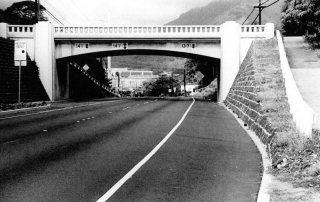
Kaahumanu Avenue-Naniloa Drive Overpass

Address Naniloa Drive at Kaahumanu Avenue, Wailuku, Maui 96793 TMK (2) 3-4-Various SHPD Historic Site Number 50-04-1541 National Register of Historic Places #08001065 Abstract Designed by Territorial Highway engineer William Bartels, the Kaahumanu Avenue-Naniloa Drive Bridge is a rigid frame concrete bridge with cantilevered ends that spans a gap in Wailuku's "Sand Hills" as it carries Naniloa Drive over Kaahumanu Avenue. The Kaahumanu Avenue-Naniloa Drive Bridge achieves state and local significance in the areas of engineering and transportation. The bridge is one of the earliest remaining rigid-frame bridges built in the Territory of Hawaii. The structure is one of two such bridges built in Hawaii in 1936. The bridge represents the advances in engineering technology being achieved in Hawaii during the early twentieth century. This list of Hawaii’s historic properties is provided as a public service by Historic Hawaii Foundation. It is not the official list of properties designated on the Hawaii State Register of Historic Places. For official designations and determinations of eligibility, contact the State Historic Preservation Division of the Department of Land and Natural Resources of the State of Hawaii at 808-692-8015.
2017-04-21T01:01:53-10:00March 3rd, 2014|Categories: Historic Properties|Tags: , |

Kalepolepo Fishpond

Address Kalepolepo Beach Park, Kihei, Maui 96753 TMK (2) 3-9-001:Various SHPD Historic Site Number 50-09-1288 National Register of Historic Places #96001503 Abstract The Kalepolepo Fishpond is situated on a fringing coral reef, with the main portion of the wall following along the outer perimeter of the reef. This type of setting was selected most frequently for the construction of loko kuapa (walled ponds), due to wave protection provided by the reef and the presence of a shallow shoal area. Kalepolepo Fishpond is significant as a well-preserved example of the technological achievements associated with the development  of Hawaiian aquaculture. The fishpond was an economic resource that was important for its subsistence value to the people of the Kula District between approximately AD 1500 and 1880. This list of Hawaii’s historic properties is provided as a public service by Historic Hawaii Foundation. It is not the official list of properties designated on the Hawaii State Register of Historic Places. For official designations and determinations of eligibility, contact the State Historic Preservation Division of the Department of Land and Natural Resources of the State of Hawaii at 808-692-8015.
2017-04-21T01:01:53-10:00March 3rd, 2014|Categories: Historic Properties|Tags: , |

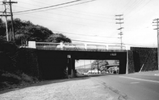
Waiale Drive Bridge

Address 51 Waiale Road, Wailuku, Maui 96793 TMK (2) 3-4-010:037 SHPD Historic Site Number 50-04-1633 National Register of Historic Places #98001287 Abstract The Waiale Drive Bridge carries Kaahumanu Avenue across Waiale Drive in Wailuku. The bridge was designed to provide a grade separation for the now-defunct Wailuku Sugar Company railroad alignment to the mill. This is one of two steel stringer-grade separations designed by William Bartels. The Waiale Drive Bridge is significant for its contributions to the fields of engineering and transportation in Hawaii. The bridge is eligible for its associations with the economic development of Maui as it provided economical transportation to the mill. It is also eligible as an uncommon example of a steel stringer bridge in Hawaii and a rare example of the use of vernacular materials on a Federal Aid bridge. This list of Hawaii’s historic properties is provided as a public service by Historic Hawaii Foundation. It is not the official list of properties designated on the Hawaii State Register of Historic Places. For official designations and determinations of eligibility, contact the State Historic Preservation Division of the Department of Land and Natural Resources of the State of Hawaii at 808-692-8015.

2017-04-21T01:01:53-10:00March 3rd, 2014|Categories: Historic Properties|Tags: , |
Go to Top