Historic Properties

Kapa‘a Stone Lantern

Address N/A Built 1915 What is it? This 15-foot cast concrete lantern was built in 1915 by Kauai's Japanese community to commemorate the Russo-Japanese War of 1905 and to honor the 1912 ascension to the throne of Emperor Taisho. By World War II, however, these pro-imperial sentiments were a problem for a later generation of Japanese- Americans who, in 1943, literally buried the lantern, both to protect it from vandalism during a time of anti-Japanese sentiment and as a display of pro-American loyalty. Once buried, it was forgotten until 1972, when the parents of children playing soccer at Kapaa Beach Park complained about a dangerous piece of steel rebar sticking out of the ground. Work crews discovered that the rebar was attached to a buried monument—but one that no one wanted to claim. The lantern was reburied 24 hours later. In 1987, Mayor Tony Kunimura led an effort to unearth the lanterns, with the help of the Kauai Historical Society. The lantern was moved to the corner of the beach park and braced. What threatens it? Exposure to the elements threatens the monument. Being buried and dug up, twice, damaged the lantern.  Now even the metal braces on the lantern are rusting and damaging the concrete. "There are several serious cracks and breaks in the concrete structure... and in many places the concrete is broken or crumbling away," reports Mary Requilman, executive director of the Kauai Historical Society. What can be done? The historical society and the Kapaa Business Association would like to restore the lantern, as part of an overall plan to revitalize Kapaa. "In 1991, we raised enough money to have the lantern appraised by a professional sculpture conservator," says Requilman. [...]

2017-04-21T01:03:12-10:00February 19th, 2014|Categories: Historic Properties|Tags: |

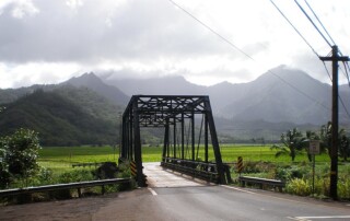
Kauaʻi Belt Road

Address Kūhiō Highway, Hawai‘i Route 560, between Princeville and Hā‘ena, Kaua‘i TMK (4) Various SHPD Historic Site Number N/A Historic District National Register of Historic Places #03001048 Abstract The Kaua‘i Belt Road between Princeville and Hā‘ena traverses 10 miles along the island’s north shore. This portion of the Kaua‘i “Belt Road” was part of  original road system, which extended from Hā‘ena on the north shore to Mana on the west shore. The road is significant in the areas of engineering, transportation, social history and commerce. The road was added to the Hawai‘i State Register of Historic Places in 2004. An amended nomination was approved in March 2022. Updates included adding a new area of significance in the field of conservation. The amendment also describes alterations to the road since the original listing, including effects of the storm event of April 2018 which caused damage by flooding, landslides and debris. The amended nomination determines the Kauaʻi Belt Road continues to be significant under Criteria A and C retaining sufficient integrity despite roadway modifications occurring after 2002. The amended nomination includes conservation as an additional area of significance at the State and local level, acknowledging substantial historic preservation efforts occurring since the 1970s. During that time, community concerns with future growth and development on the North Shore spurred public outcry to Hawai‘i Department of Transportation’s widening of Hanalei Bridge and proposals to alter Kaua‘i Belt Road with the community desiring to preserve its rural nature. Hanalei Belt Road is recognized as a character defining feature of Kaua‘i’s greater North Shore cultural landscape representing the natural and cultural history of the area. [...]

2022-07-21T11:30:23-10:00February 19th, 2014|Categories: Historic Properties|Tags: , |

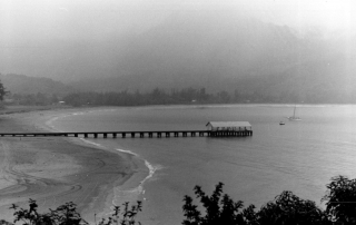
Hanalei Pier

Address Hanalei Bay (north end of Weke Road), Hanalei, Kauai 96714 TMK (4) 5-5-001:008 SHPD Historic Site Number 30-03-9382 National Register of Historic Places #79000757 Abstract The Hanalei Pier is a steel-reinforced concrete finger pier which extends from the beach out into Hanalei Bay. The pier, when built, had a wooden deck. It was replaced in 1922 with a concrete deck. The pier is 340 feet long and has a shed at its terminus. The shed is a frame structure with a corrugated iron gable roof. Hanalei Pier is a good example of a typical finger pier constructed in the 1920s in Hawaii, and is important for its associations with transportation history in Hawaii. It is also one of the last remaining vestiges of the rice industry in Hanalei. The pier was used seasonally, primarily to transport rice from Hanalei to Honolulu. This list of Hawaii’s historic properties is provided as a public service by Historic Hawaii Foundation. It is not the official list of properties designated on the Hawaii State Register of Historic Places. For official designations and determinations of eligibility, contact the State Historic Preservation Division of the Department of Land and Natural Resources of the State of Hawaii at 808-692-8015.

2017-04-21T01:03:13-10:00February 19th, 2014|Categories: Historic Properties|Tags: , |

Cook Landing Site

Address South of the intersection of Kahakai Road and Alawai Road, Waimea, Kauai 96796 TMK (4) 1-6-001:888, -006:001 (portion of each) SHPD Historic Site Number 30-05-9303 National Historic Landmark National Register of Historic Places #66000298 Abstract The Cook Landing Site (the beach at Waimea) was the spot where Captain James Cook, the first European known to have sighted the Hawaiian Islands, made his initial landing upon island soil on January 20, 1778. The sandy beach now has a national historic landmark plaque displayed on a pedestal in the extreme east corner of that portion near the river embankment. Due to large environmental changes, the landmark must be understood as a commemorative site where Cook's expedition's activities first took place, in addition to the start of Western civilization influencing the native culture and population. This list of Hawaii’s historic properties is provided as a public service by Historic Hawaii Foundation. It is not the official list of properties designated on the Hawaii State Register of Historic Places. For official designations and determinations of eligibility, contact the State Historic Preservation Division of the Department of Land and Natural Resources of the State of Hawaii at 808-692-8015.

2017-04-21T01:03:13-10:00February 19th, 2014|Categories: Historic Properties|Tags: , |

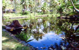
Weuweu-Kawai-iki Fishpond

Address Corner of Kuamo‘o Road and Kuhio Highway, Wailua, Kauai 96746 TMK (4) 4-1-003:007 SHPD Historic Site Number 30-03-9052 Abstract Weuweu-Kawai-iki Fishpond is comprised of two historic fishponds. Today the pond exists as a landscape water feature on the (former) Coco Palms hotel property. The fishponds’ original extent and shape are currently unknown. The property is significant as a traditional Hawaiian fishpond, owned by a member of the ali‘i in the nineteenth century and possibly predating this time period back before Western contact in A.D. 1778. This list of Hawaii’s historic properties is provided as a public service by Historic Hawaii Foundation. It is not the official list of properties designated on the Hawaii State Register of Historic Places. For official designations and determinations of eligibility, contact the State Historic Preservation Division of the Department of Land and Natural Resources of the State of Hawaii at 808-692-8015.

2017-04-21T01:03:13-10:00February 19th, 2014|Categories: Historic Properties|Tags: |

Kapaia Swinging Bridge

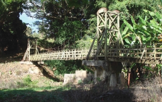
Address End of Laukini Road to Kapaia Road, Lihue, Kauai, 96766 TMK (4) 3-7-001:009, :001 (portion of each) SHPD Historic Site Number 30-11-9077 Abstract The Kapaia Swinging Bridge is 125 feet long and provides a 4-foot-wide pedestrian walkway comprised of wooden planks and girders over Kapaia Stream. Two steel cables run the length of the bridge, are secured to concrete/boulder anchorages on either side, and suspend the structure via a series of hangers located between two wooden towers that are fixed to concrete piers. The Kapaia Swinging Bridge is historically significant in the areas of transportation and ethnic heritage for its association with the sugar plantation history and multicultural heritage of the Kapaia Valley community. It is also significant as one of very few examples of suspension bridge engineering in Hawaii. This list of Hawaii’s historic properties is provided as a public service by Historic Hawaii Foundation. It is not the official list of properties designated on the Hawaii State Register of Historic Places. For official designations and determinations of eligibility, contact the State Historic Preservation Division of the Department of Land and Natural Resources of the State of Hawaii at 808-692-8015.

2017-04-21T01:03:13-10:00February 19th, 2014|Categories: Historic Properties|Tags: |

Opaekaa Road Bridge

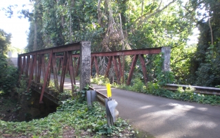
Address Opaekaa Road over Opaekaa Stream, Kapaa, Kauai 96746 TMK N/A SHPD Historic Site Number 30-08-9377 National Register of Historic Places #83000253 Abstract The Opaekaa Road Bridge is a single-lane, wrought-iron, Warren truss bridge that terminates with vertical end posts. The bridge is 73 feet long and its trusses consist of 7 panels, each approximately 10 feet in length and 9 feet 8 inches tall. The Opaekaa Road Bridge is significant as the only known British-made iron bridge in the United States, and one of the few surviving iron bridges in the State of Hawaii. The bridge is also significant because of its associations with the development of the Wailua Homesteads. This list of Hawaii’s historic properties is provided as a public service by Historic Hawaii Foundation. It is not the official list of properties designated on the Hawaii State Register of Historic Places. For official designations and determinations of eligibility, contact the State Historic Preservation Division of the Department of Land and Natural Resources of the State of Hawaii at 808-692-8015.

2017-04-21T01:03:13-10:00February 19th, 2014|Categories: Historic Properties|Tags: , |

Puuopae Bridge

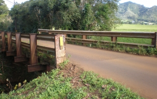
Address Puuopae Road over Kalama Stream, Kapaa, Kauai 96746 TMK N/A SHPD Historic Site Number 30-08-9397 National Register of Historic Places #05000536 Puuopae Bridge Nomination Form (PDF) Abstract The Puuopae Bridge is a one-lane, 48-foot long, single-span bridge that carries Puuopae Road over Kalama Stream. Constructed in 1915, Puuopae Bridge provided an important transportation conduit that contributed to the successful development of the homesteading lands on the east side of Kauai. The bridge is significant both for its links to the development of the Kapaa Homesteads as well as the direct involvement of that community in pressuring the government to provide adequate stream crossings and roads in the area. This list of Hawaii’s historic properties is provided as a public service by Historic Hawaii Foundation. It is not the official list of properties designated on the Hawaii State Register of Historic Places. For official designations and determinations of eligibility, contact the State Historic Preservation Division of the Department of Land and Natural Resources of the State of Hawaii at 808-692-8015.

2017-04-21T01:03:13-10:00February 19th, 2014|Categories: Historic Properties|Tags: , |

Grove Farm Company Locomotives

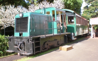
Address 200 yards from Puhi Road, Lihue, Kauai 96766 TMK (4) 3-3-002:015 SHPD Historic Site Number 30-11-9381 National Register of Historic Places #79000761 Abstract Grove Farm Company has four locomotives – Paulo, Wainiha, Wahiawa, and Kaipu – each have many unique features and were originally used to transport sugar and are currently being stored in a Grove Farm Company warehouse. They have achieved varying levels of restoration with Kaipu and Paulo being operational. These four locomotives chronicle the development of steam-powered sugar trains in Hawaii and are the only four locomotives left on Kauai. This list of Hawaii’s historic properties is provided as a public service by Historic Hawaii Foundation. It is not the official list of properties designated on the Hawaii State Register of Historic Places. For official designations and determinations of eligibility, contact the State Historic Preservation Division of the Department of Land and Natural Resources of the State of Hawaii at 808-692-8015.

2017-04-21T01:03:13-10:00February 19th, 2014|Categories: Historic Properties|Tags: , |

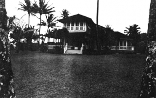
5174 Weke Road/ Sanborn Beach House

Address 5174 Weke Road, Hanalei, Kauai 96714 TMK (4) 5-5-002:094 SHPD Historic Site Number 30-01-9043 Download Nomination Form Abstract A two-story wood frame, plantation style home with board and batten walls, hip and valley roof line, cedar shingles, and overhanging eaves. This beach front home features panoramic views and interior Craftsman style detailing including elaborate trim work on the ceilings. The house is the first beach front home to be constructed in the area and is significant for its association with the history and development of the community of Hanalei. It is also significant as an example of a late nineteenth- and early twentieth-century Craftsman style house built in Hawaii. This list of Hawaii’s historic properties is provided as a public service by Historic Hawaii Foundation. It is not the official list of properties designated on the Hawaii State Register of Historic Places. For official designations and determinations of eligibility, contact the State Historic Preservation Division of the Department of Land and Natural Resources of the State of Hawaii at 808-692-8015.

2017-04-21T01:03:14-10:00February 14th, 2014|Categories: Historic Properties|Tags: |
Go to Top