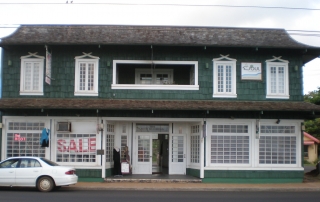
Yearly Archives: 2014

Seto Building

Address Intersection of Kuhio Highway and Lehua Street, Kapaa, Kauai 96746 TMK (4) 4-5-011:031 SHPD Historic Site Number 30-08-9379 National Register of Historic Places #79000758 Abstract The Seto Building is a two-story building of wood-frame double-walled construction built on a concrete slab foundation. The exterior walls are covered with striated, staggered wood shingles, and the interior walls and ceiling are covered with pressed fiberboard. The Seto Building is a fine example of early commercial architecture on Kauai. The building's owner, Ah Doi Seto, came to Hawaii as a sugar contract laborer from China in 1888. This list of Hawaii’s historic properties is provided as a public service by Historic Hawaii Foundation. It is not the official list of properties designated on the Hawaii State Register of Historic Places. For official designations and determinations of eligibility, contact the State Historic Preservation Division of the Department of Land and Natural Resources of the State of Hawaii at 808-692-8015.

2017-04-21T01:03:12-10:00February 19th, 2014|Categories: Historic Properties|Tags: , |

Civilian Conservation Corps Camp

Address Kokee State Park, 3600 Kokee Road, Kekaha, Kauai 96796 TMK N/A SHPD Historic Site Number N/A National Register of Historic Places #96001504 Abstract The old Civilian Conservation Corps Camp in Kokee State Park is a complex of eleven wood-frame buildings surrounding an open grassed quadrangle. These simple "rustic" style buildings were constructed in 1935 and are sheltered on three sides by koa/ohia montane forest. This camp is significant as an intact example of the camps built by the Civilian Conservation Corps that were established throughout the United States in natural areas. Of the five original camps that were built in Hawaii, Kokee is the only C.C.C. Camp that remains a natural area. This list of Hawaii’s historic properties is provided as a public service by Historic Hawaii Foundation. It is not the official list of properties designated on the Hawaii State Register of Historic Places. For official designations and determinations of eligibility, contact the State Historic Preservation Division of the Department of Land and Natural Resources of the State of Hawaii at 808-692-8015.

2017-04-21T01:03:12-10:00February 19th, 2014|Categories: Historic Properties|Tags: , |

Koloa Jodo Mission

Address N/A Built 1909 What is It? Built in 1909 by Rev. Jissei Muroyama, the Koloa Jodo Mission was one of Kaua‘i’s first Japanese temples, erected by immigrants who settled in the area. The mission built a larger temple to replace the aging structure in the 1980s, and it has since been used as a columbarium (a place for urns). Lorraine Minatoishi-Palumbo, an architect with expertise in Hawai‘i’s traditional Japanese architecture, calls the temple a fine example of early period Japanese temples built in the Islands, and says it’s one of only a handful still standing. What threatens it? The temple is beginning to feel its age, particularly in the past two years. The mission’s minister, Rev. Ishikawa, says, “We still use the building as a columbarium, but the ceiling is falling down and there’s also termite damage. I feel it’s become dangerous to use.” According to Minatoishi-Palumbo, the situation is a result of changing times. “What has been traditional in the upkeep of these temples is that the congregations would maintain them,” she says. “A lot of the Japanese men were carpenters, but everyone has gotten older.” At this point, many in the congregation are pushing to simply demolish the temple. Ishikawa says he’d like to save it, although he’s not sure what repairs would cost. What can be done? Minatoishi-Palumbo plans to submit the Koloa Jodo Mission to the state and national historic registers, which, if approved, will make it easier to apply for bricks and mortar grants. Another interesting prospect: A former minister of the temple, Rev. Kodo Tanaka, visited the mission in June, and after seeing the condition of the structure, raised the possibility of [...]

2017-04-21T01:03:12-10:00February 19th, 2014|Categories: Historic Properties|Tags: |

Kokee Park

Address N/A Built N/A Abstract On December 31, 2006, the current leases for 114 recreation residences at Koke‘e and Waimea Canyon State Parks will expire. The issuing of new leases in this case is subject to historic preservation review (Section 6E-8, HRS, and Chapter 13-275, HAR) because approximately 92 of these buildings (i.e., 81%) were built over 50 years ago and their continued use under new lease agreements could affect significant historic properties. HHF concurs with the finding of the Department of State Parks that the recreation residences are collectively significant as a historic district, with over 75 of the cabins considered contributing structures. Project Description The 114 recreation residences being considered for lease in 2007 are grouped in three distinct clusters of lots called the Pu`u ka Pele, Halemanu, and the Koke`e Camp Lots. These three camp lots encompass a total of 135 lots that were established between 1918 and 1951 specifically as a recreational retreat in the cool uplands for those able to escape the hot summers along the coast. Construction of the existing cabins began in the 1920s and continued through the 1990s. The 48 recreation residences in the Kokee Camp Lots and the 14 residences in the Halemanu Camp Lots are located within Kokee State Park. The 43 residences at the Pu`u ka Pele Camp Lots fall within Waimea Canyon State Park. When combined, the 135 lots have a total acreage of 133 acres. Kokee Cabin, From HHF Archives The Department of State Parks is considering options for leasing the lots, either through auction, direct negotiation or lottery. A master lease could be issued to encompass all or a major portion of the [...]

2017-04-21T01:03:12-10:00February 19th, 2014|Categories: Historic Properties|Tags: |

Kekaha Sugar Mill

Address N/A Built 1898 What Is It? Kekaha Town literally grew up around this mill. From the founding of Kekaha Sugar Co. in 1898 until the end of sugar operations in 2000, the mill provided the area its main economic driver, not to mention one of its most prominent landmarks: the smokestack that still towers above the town. It may not look it today, but the Kekaha Sugar Mill is actually the most modern sugar facility in Hawai‘i—it was built in 1954 as an upgrade to older, smaller mills before it. What threatens it? In a general sense, the wane of the sugar era on Kaua‘i means that plantation towns such as Kekaha and Lıhu‘e are faced with reinventing themselves. The mills that defined these towns may fall victim to the search for new commercial activity. Specifically, Pahio Development Inc., the company that bought the Kehaha Mill property earlier this year, and which also owns Lıhu‘e Mill, may be looking into replacing the structure with a new development, although president and CEO Lynn McCrory won’t say exactly what kind. “We’re still looking at the options for the site,” she says. “We’d like to take a bit more time looking at those possibilities and moving forward on them.” What can be done? Jose Bulatao, vice-chair of the Kaua‘i West Side Watershed Council and a lifelong resident of Kekaha, says he wants Pahio Development to involve the Kekaha community in the discussion over what to do with the mill property. He acknowledges that it may be a costly endeavor to adapt the buildings to a new use. But Bulatao says it would be worth the trouble. “We would like the [...]

2017-04-21T01:03:12-10:00February 19th, 2014|Categories: Historic Properties|Tags: |

Coco Palms Resort

Address N/A Built N/A What Is It? The Coco Palms is one of Hawaii's most renowned classic resorts. Owner Grace Guslander pioneered romantic traditions that have become de rigueur in the local hospitality industry, such as the torch-lighting ceremony. The site's historical significance predates the resort, though. It was long a favorite center for Hawaiian monarchy; High Chief Deborah Kapule lived there in the mid-1800s, and cultivated fishponds in the area. What threatens it? Hurricane Iniki hit the resort hard in 1992, and the Coco Palms has been shuttered ever since. Not for lack of interest in reopening it. As Kauai historian Pat Griffin says, "There is general agreement that it is an enormously important cultural and historical site, and should be protected." But no one has yet been able to make the numbers work. What can be done? There are a couple of ideas afloat, but both of them require money that hasn't materialized yet. The property's current owner, Phillip Ross, of Coco Palms Ventures LLC, based in Annapolis, Md., says he's working to re-open the Coco Palms in its original retro look, but needs a partner. "We've invested more than $6.5 million in securing our SMA (shoreline management area) and various other use permits, and preparation of construction documents in order to advance the project," he says. "We're seeking a joint venture partner or a sale to a developer who can develop the property in keeping with our vision." Some local community groups, as well as state Sen. Gary Hooser, would rather see the property turned into a community based educational park facility. But this plan has no financial backing either.

2017-04-21T01:03:12-10:00February 19th, 2014|Categories: Historic Properties|Tags: |

Kapa‘a Stone Lantern

Address N/A Built 1915 What is it? This 15-foot cast concrete lantern was built in 1915 by Kauai's Japanese community to commemorate the Russo-Japanese War of 1905 and to honor the 1912 ascension to the throne of Emperor Taisho. By World War II, however, these pro-imperial sentiments were a problem for a later generation of Japanese- Americans who, in 1943, literally buried the lantern, both to protect it from vandalism during a time of anti-Japanese sentiment and as a display of pro-American loyalty. Once buried, it was forgotten until 1972, when the parents of children playing soccer at Kapaa Beach Park complained about a dangerous piece of steel rebar sticking out of the ground. Work crews discovered that the rebar was attached to a buried monument—but one that no one wanted to claim. The lantern was reburied 24 hours later. In 1987, Mayor Tony Kunimura led an effort to unearth the lanterns, with the help of the Kauai Historical Society. The lantern was moved to the corner of the beach park and braced. What threatens it? Exposure to the elements threatens the monument. Being buried and dug up, twice, damaged the lantern.  Now even the metal braces on the lantern are rusting and damaging the concrete. "There are several serious cracks and breaks in the concrete structure... and in many places the concrete is broken or crumbling away," reports Mary Requilman, executive director of the Kauai Historical Society. What can be done? The historical society and the Kapaa Business Association would like to restore the lantern, as part of an overall plan to revitalize Kapaa. "In 1991, we raised enough money to have the lantern appraised by a professional sculpture conservator," says Requilman. [...]

2017-04-21T01:03:12-10:00February 19th, 2014|Categories: Historic Properties|Tags: |

Kauaʻi Belt Road

Address Kūhiō Highway, Hawai‘i Route 560, between Princeville and Hā‘ena, Kaua‘i TMK (4) Various SHPD Historic Site Number N/A Historic District National Register of Historic Places #03001048 Abstract The Kaua‘i Belt Road between Princeville and Hā‘ena traverses 10 miles along the island’s north shore. This portion of the Kaua‘i “Belt Road” was part of  original road system, which extended from Hā‘ena on the north shore to Mana on the west shore. The road is significant in the areas of engineering, transportation, social history and commerce. The road was added to the Hawai‘i State Register of Historic Places in 2004. An amended nomination was approved in March 2022. Updates included adding a new area of significance in the field of conservation. The amendment also describes alterations to the road since the original listing, including effects of the storm event of April 2018 which caused damage by flooding, landslides and debris. The amended nomination determines the Kauaʻi Belt Road continues to be significant under Criteria A and C retaining sufficient integrity despite roadway modifications occurring after 2002. The amended nomination includes conservation as an additional area of significance at the State and local level, acknowledging substantial historic preservation efforts occurring since the 1970s. During that time, community concerns with future growth and development on the North Shore spurred public outcry to Hawai‘i Department of Transportation’s widening of Hanalei Bridge and proposals to alter Kaua‘i Belt Road with the community desiring to preserve its rural nature. Hanalei Belt Road is recognized as a character defining feature of Kaua‘i’s greater North Shore cultural landscape representing the natural and cultural history of the area. [...]

2022-07-21T11:30:23-10:00February 19th, 2014|Categories: Historic Properties|Tags: , |

Hanalei Pier

Address Hanalei Bay (north end of Weke Road), Hanalei, Kauai 96714 TMK (4) 5-5-001:008 SHPD Historic Site Number 30-03-9382 National Register of Historic Places #79000757 Abstract The Hanalei Pier is a steel-reinforced concrete finger pier which extends from the beach out into Hanalei Bay. The pier, when built, had a wooden deck. It was replaced in 1922 with a concrete deck. The pier is 340 feet long and has a shed at its terminus. The shed is a frame structure with a corrugated iron gable roof. Hanalei Pier is a good example of a typical finger pier constructed in the 1920s in Hawaii, and is important for its associations with transportation history in Hawaii. It is also one of the last remaining vestiges of the rice industry in Hanalei. The pier was used seasonally, primarily to transport rice from Hanalei to Honolulu. This list of Hawaii’s historic properties is provided as a public service by Historic Hawaii Foundation. It is not the official list of properties designated on the Hawaii State Register of Historic Places. For official designations and determinations of eligibility, contact the State Historic Preservation Division of the Department of Land and Natural Resources of the State of Hawaii at 808-692-8015.

2017-04-21T01:03:13-10:00February 19th, 2014|Categories: Historic Properties|Tags: , |

Cook Landing Site

Address South of the intersection of Kahakai Road and Alawai Road, Waimea, Kauai 96796 TMK (4) 1-6-001:888, -006:001 (portion of each) SHPD Historic Site Number 30-05-9303 National Historic Landmark National Register of Historic Places #66000298 Abstract The Cook Landing Site (the beach at Waimea) was the spot where Captain James Cook, the first European known to have sighted the Hawaiian Islands, made his initial landing upon island soil on January 20, 1778. The sandy beach now has a national historic landmark plaque displayed on a pedestal in the extreme east corner of that portion near the river embankment. Due to large environmental changes, the landmark must be understood as a commemorative site where Cook's expedition's activities first took place, in addition to the start of Western civilization influencing the native culture and population. This list of Hawaii’s historic properties is provided as a public service by Historic Hawaii Foundation. It is not the official list of properties designated on the Hawaii State Register of Historic Places. For official designations and determinations of eligibility, contact the State Historic Preservation Division of the Department of Land and Natural Resources of the State of Hawaii at 808-692-8015.

2017-04-21T01:03:13-10:00February 19th, 2014|Categories: Historic Properties|Tags: , |
Go to Top