Oahu Non-Designated

Kaimuki: A Brief History

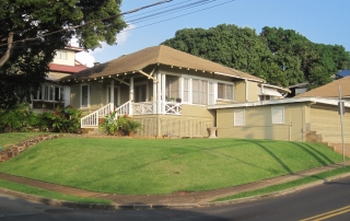
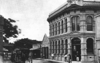
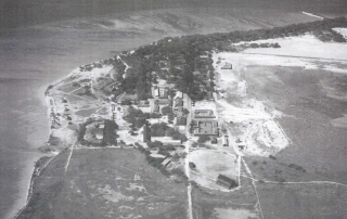
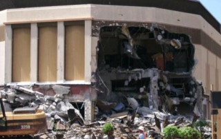
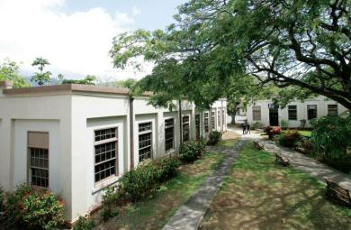
Address Honolulu, HI 96816 Built From 1898 Dry, dusty Kaimuki The observatory was an ideal place to watch Haley's Comet in 1910. Kapahulu Ave. under construction Kaimuki trolley Waialae Avenue storefronts c. 1920 Queen Theater on Waialae Ave. was an anchor in Kaimuki's business district. Kaimuki Fire Station was built in 1924 in a Spanish Mission Style designed by G.R. Miller. The former Lam residence was a landmark for over 100 years before it was demolished and replaced by a two-home compound surrounded by a six-foot wall. Photo by Jill Byus Radke Large duplexes are replacing historic homes, destroying the character of the neighborhood, which diminishes the value of neighboring homes (aka "The Teardown Trend"). Photo by Jill Byus Radke By Jill Byus Radke for Historic Hawaii Foundation Kaimuki is a classic early twentieth century neighborhood on the Koko Head side of downtown Honolulu. Kaimukī means ‘tī oven', a reference to the legend of the Menehune cooking tī roots in the area. Kaimuki is a naturally dusty, dry area that was not heavily populated during precontact times because of a lack of water. The only spring known today is on Luakaha Street near the Salvation Army. There were up to four heiau in the Kaimukī area: Maumae (Sierra Drive) Honolulu side of Kaimuki Hill Between Ocean View Drive and former Waialae Drive-In Parking lot at Lē‘ahi Hospital Early Land Uses When King Kamehemeha stationed his troops on the beaches of Waikīkī in preparation for the battle of O‘ahu, he stationed lookouts at Kaimukī to spot enemies arriving by sea. Pu‘u o [...]

2017-04-21T01:01:37-10:00May 23rd, 2014|Categories: Historic Properties|Tags: |

Ford Island

Address N/A Built N/A Bridge to Ford Island What is it? Ford Island is a 450-acre site at the heart of the Pearl Harbor historic district. Though the island's first use was for large-scale sugar cultivation, it was acquired by the U.S. government for Army and Navy development and transformed into a major air facility in the late 1930s. Shortly after the first wave of Japanese aircraft flew over Pearl Harbor at 7:55 a.m. on Dec. 7, 1941, the USS Arizona exploded and sank with 1,177 of her crew in less than nine minutes. By 10 a.m., 21 vessels lay sunken or damaged, the air full of smoke and death. Americans, previously divided over the issue of U.S. involvement in World War II, rallied to enter and win the war. Read more Background on Ford Island. What threatens it? In 1999 National Trust and the Historic Hawaii Foundation first learned that the Navy planned a major housing development, a festival market place, and a recreational marina on Ford Island. The National Trust expressed concern over the plans in a letter to then-Secretary of the Navy Richard Danzig. Despite ongoing efforts since then-including nearly two years of discussions-resolution has not occurred regarding the future of this landmark and the Navy's plans for developing housing, commercial and recreational uses. The Navy has asked potential developers to be sensitive to the island's historic character, but the Navy's need for new facilities has caused it to move forward without completing the preservation planning needed for one of the nation's most significant 20th-century landmarks. What can be done? An agreement must be worked out with the Navy to ensure that development [...]

2017-04-21T01:01:38-10:00May 2nd, 2014|Categories: Historic Properties|Tags: |

Auwai of Nuuanu Valley (2008)

Photos: Courtesy of Rae Huo Article Written By: Michael Keany, HONOLULU Magazine What is it? Centuries ago, Nuuanu Valley was one of Oahu’s primary bread baskets, filled with taro, breadfruit and other staples of the Hawaiian diet. In order to irrigate their crops, Hawaiians built an elaborate system of ditches, called auwai, that diverted water from Nuuanu Stream, through the loi and then returned it to the stream. What threatens it? As Nuuanu Valley transitioned from agricultural to residential use, the land under the auwai was split up into smaller parcels, complicating oversight of the system. The Board of Water Supply once maintained the auwai, but today the task falls to the individual property owners in the neighborhood.  Attention to the auwai is spotty; out of 14 original auwai, there are now about eight that are either flowing or could be repaired. “New people move in and don’t understand what they’ve got in their backyards. They fill it in to have something else there,” says Shannon Wilson of the Nuuanu Valley Auwai Study Group, a neighborhood volunteer group dedicated to restoring the auwai. “It’s in everyone’s deed that they have to take care of their section of the waterway, but people don’t always read the fine print.” What can be done? At this point, it’s a matter of public education, making sure property owners with auwai segments know the best way to take care of them. The Nuuanu Valley Auwai Study Group is doing its best to spread the word. They’ll even handle the dirty work of repairing and maintaining an auwai section, if a property owner is unable. For more information, call Wilson at 595-2914.

2016-11-17T09:13:49-10:00March 3rd, 2014|Categories: MES Oahu|Tags: , |

University of Hawaii at Manoa Engineering Quads (2008)

Photos: Courtesy of Rae Huo Article Written By: Michael Keany, HONOLULU Magazine What Is It? These four buildings next to the University of Hawai‘i at Manoa’s Campus Center constitute some of the oldest buildings on campus—their small size a reminder of how much the school has grown since its early days. One of them, the Engineering Materials Testing Laboratory, built in 1915, is predated only by Hawai‘i Hall. The buildings housed the Engineering School until 1959. Today, they provide a home for Ka Leo, UH’s student newspaper, the Board of Publications, Student Support Services, Duplicating Services and the now-empty Beau Press. What threatens it? A proposed $38 million expansion of the Campus Center that would include a fitness center and gym for students, as well as a heritage corridor commemorating the university’s 100-year-history. The footprint of the new complex, at least as it’s currently planned, lies directly over the historic quad, meaning the four buildings would need to be demolished to make way. Astrid Liverman, architectural branch chief at the state Historic Preservation Division, says, “It’s ironic that in order to build a Heritage Corridor, they’re going to remove the heritage.” What can be done? Because UH Mānoa is a state agency, it’s required by law to get the concurrence of the SHPD before starting any project that impacts historic property. Liverman has thus far opposed the idea of demolishing the Engineering Quad buildings, and says she’s holding out either for a revised plan that incorporates the four buildings into the new complex, or at least a compromise that saves some of the buildings. Kathy Cutshaw, the UH Mānoa vice chancellor for administration, finance and operations, is overseeing the project, but didn’t return our calls.

2016-11-17T09:14:03-10:00March 3rd, 2014|Categories: MES Oahu|Tags: , |

Bishop & Co.

Address 65 Merchant Street, Honolulu, HI Built 1878   Designed By T.J. Baker Abstract In August, 1858, Charles Reed Bishop and W.A. Aldrich opened the first permanent banking establishment in Honolulu.  Twenty years later, Bishop purchased the corner of Merchant and Kaahumanu property for a new bank building.  The brick two-story building was completed in 1878 by builder T.J. Baker.   In 1923,  the bank moved to a larger headquarters and the building has been leased as office space ever since. This list of Hawaii’s historic properties is provided as a public service by Historic Hawaii Foundation. It is not the official list of properties designated on the Hawaii State Register of Historic Places. For official designations and determinations of eligibility, contact the State Historic Preservation Division of the Department of Land and Natural Resources of the State of Hawaii at 808-692-8015.

2017-04-21T01:02:43-10:00February 28th, 2014|Categories: Historic Properties|Tags: |

Fort Kamehameha

Address Hickam AFB HI, 96853 Abstract By Michael Keany, Courtesy of Honolulu Magazine What is it? Built in 1916, Fort Kamehameha was originally an Army Coastal Artillery Post. After World War II, however, coastal artillery became obsolete, and most of the non-residential buildings were demolished. The remaining 33 homes stand as great examples of the Bungalow/Arts and Crafts style of the era, earning it a spot on the National Register of Historic Places in 1984. What threatens it?   The Air Force has announced that it intends to dispose of the historic district by the end of 2009. The reason given: Apparently Fort Kamehameha’s location underneath the flight path of runways at Honolulu International Airport puts it in an “accident potential zone.” In a letter to the state Historic Preservation Division explaining the regulation, Air Force environmental flight chief Richard Parkinson wrote, “The risks of aircraft accidents, as well as noise levels, are at an unacceptable level for family housing.”   What can be done? “We’re doing an environmental impact statement right now,” says Air Force public information officer Master Sgt. Robert Burgess. “There are five or six [disposal] options on the table, and the decision will be made once we have all the information in.” Those options include demolishing some or all of the homes.   Astrid Liverman, architectural branch chief of the state Historic Preservation Division, says her department has offered to lease Fort Kamehameha from the Air Force for 10 years, which would preserve the historic district without requiring an EIS, but the Air Force has elected to continue with the study. “If the determination of the EIS is that demolition is an acceptable solution, we [...]

2017-04-21T01:02:43-10:00February 28th, 2014|Categories: Historic Properties|Tags: |

Waimalu Stream Bridge

Address Kamehameha Hwy at Waimalu Stream (near Ka'ahumanu St) Built 1936, 1945, 1966 Abstract This bridge is associated with the roadway infrastructure of Kamehameha Hwy in the Pearl City/Aiea area.  Kamehameha Hwy has been a major transportation route through the Pearl City/ Aiea area since the early decades of the 20th century.  The bridges constructed over this crossing at Waimalu Stream have been significantly integral to its development as an effective transportation route and have contributed meaningfully to development of this geographic area.  They also have facilitated major passage through the area to points east and west that are served by the highway and are representative of important public works projects initiated by the Territorial and State governments.

2017-04-21T01:02:43-10:00February 21st, 2014|Categories: Historic Properties|Tags: |

Waikele Stream Bridge & Bridge over OR&L Spur

Address Farrington Highway at Waikele Stream Built 1939 Abstract Both are concrete deck girder bridges. The one over the stream has three spans with a combined length of about 130'. At the ends of the bridge the spans are supported on board formed concrete abutments. Two rows of four slender concrete columns carry the spans across Waikele Stream. The concrete parapets of the bridge are pierced to form balustrades with vertically oriented openings in the form of a thick cross (commonly referred to as a "Greek-cross void"), which was a standardized pattern in that period of Territorial Highway Department bridges.   The Waikele Stream Bridge and Bridge over OR&L Spur are significant for their associations with the development of the Waipahu community and the transportation history of the area. In addition, these bridges are good examples of concrete deck girder bridges of the late 1930s period. These bridges are associated with several important community improvement projects, the stream realignment and the construction of Farrington Highway, which greatly affected the history of Waipahu. 

2017-04-21T01:02:44-10:00February 21st, 2014|Categories: Historic Properties|Tags: |

Waiawa Stream Bridge

Address Farrington Highway west-bound over Waiawa Stream Built 1932 Abstract This six-span, reinforced-concrete bridge is a continuous deck girder type, measuring 332 feet in length, about 34 feet in width, and approximately 30 feet in height above the stream bed.  The concrete parapets of the bridge are pierced to form balustrades with arched- topped openings.  This arched-top design was a standardized pattern of Territorial Highway Department bridges of the early 1930s.  The balustrades on this bridge are divided by stanchions into six segments, each about 20' long. Each segment has cast end pieces with a recessed panel; each pair of end pieces forms a stanchion.  The end segments of parapets are slightly curved as they approach the larger end stanchions. These end stanchions are rectangular, and have rectangular panels with an incised border.  The panels are inscribed "Waiawa" and, on the opposite end stanchion, "1932."   This bridge originally carried Kamehameha Highway to the Ewa Junction and represents a road-straightening improvement project that replaced an earlier, more winding, road segment and smaller bridge crossing of Waiawa Stream.  Merritt A. Trease was the design engineer.  This bridge carried Kamehameha Highway until the bypass was built in about 1940, when this bridge and road segment became an extension of Farrington Highway. Waiawa Stream Bridge is a good example of an early 1930s continuous deck girder bridge. Its relatively long length indicates the importance of this transportation link in the circle-island main road system.   This bridge is eligible for the Hawaii State Register of Historic Places because of its association with the development of the Waipahu community and the transportation history of the area. It is also eligible because it [...]

2017-06-01T09:55:58-10:00February 21st, 2014|Categories: Historic Properties|Tags: |

Varsity Theater (Demolished 2008)

The Varsity Theater: What can we learn from this? The owners cited structural damage such as cracks, mold and a rusted pile as justification for demolishing a landmark of the community. From the public vantage point, it is difficult to know if the damage was significant enough to justify the demolition of the building, or if that was a rationalization that masked the true motives. All buildings need regular maintenance and period capital improvements to remain viable. Absent regular upkeep, significant one-time repairs and rehabilitation can compensate for incremental deterioration. Unsightliness can be reversed; dirt and mold can be cleaned; cracks can be repaired. The owners cited an unsafe building, but did not use evaluations by professional engineers and architects trained in preservation techniques, who could bring that perspective and expertise to the analysis. It may be that the damage was too great and the costs were too high; but it may not. Absent the analysis, it is unknown. Absent the building, it will never be known. What we do know is that the owner felt that the property was worth more without the historic building on it. Demolishing the architectural gem, filling our scarce landfills with its rubble (using fuel to transport it), importing more materials from elsewhere (more fuel) to build another building or pave a parking lot was perceived as a better fiscal decision than preserving, rehabilitating and using it. What can we do to remedy this? It’s too late for the Varsity Theater. But it need not be too late for other buildings in Mō‘ili‘ili, or Kaka‘ako, or Wai‘alae, or the other communities that have historic buildings that are part of the fabric of the street, [...]

2017-04-21T01:02:44-10:00February 21st, 2014|Categories: Historic Properties|Tags: |
Go to Top