MostEndangered2012

Marconi Wireless Telegraph Station (2012)

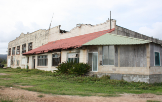
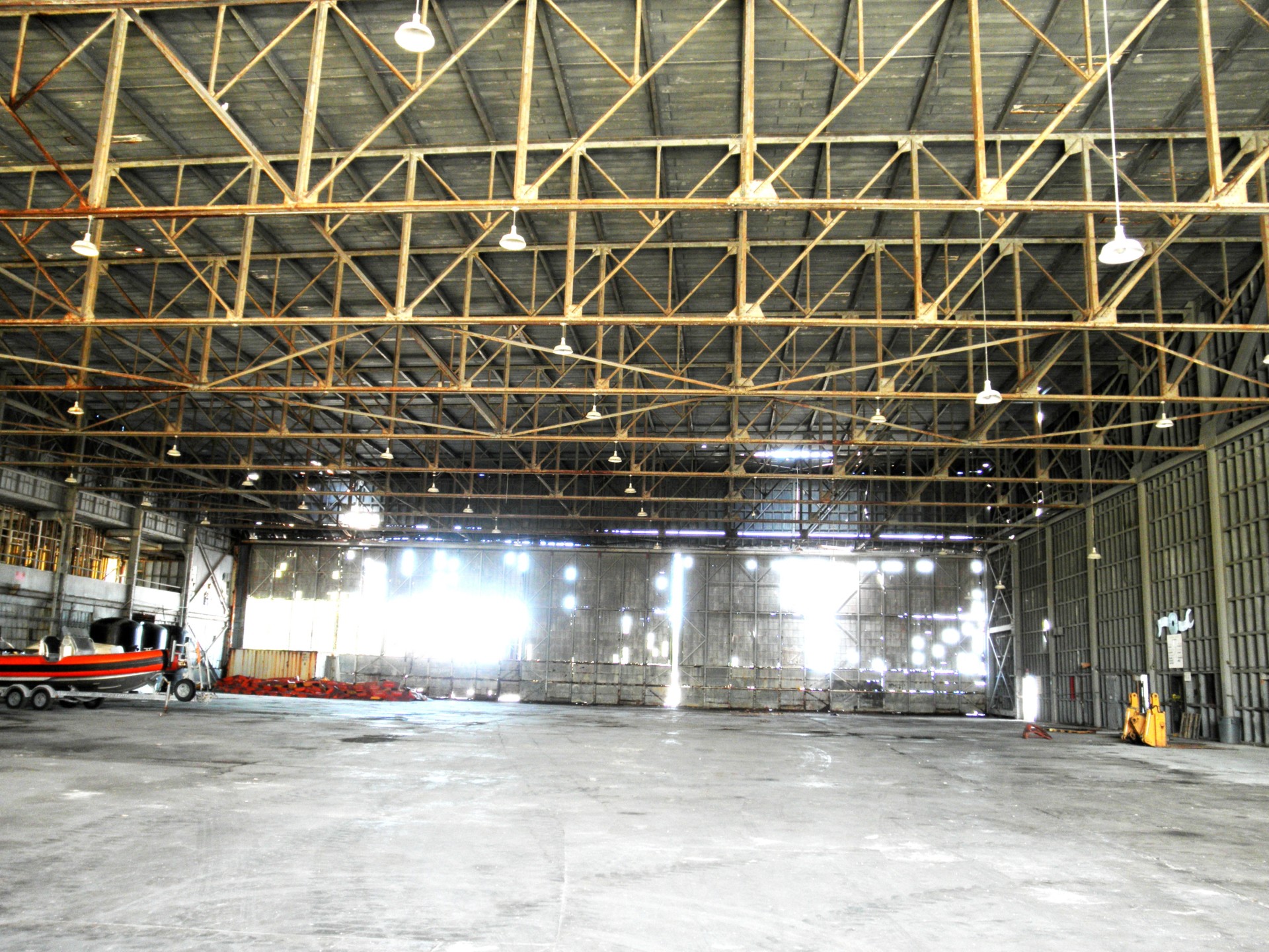
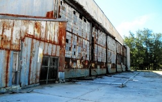
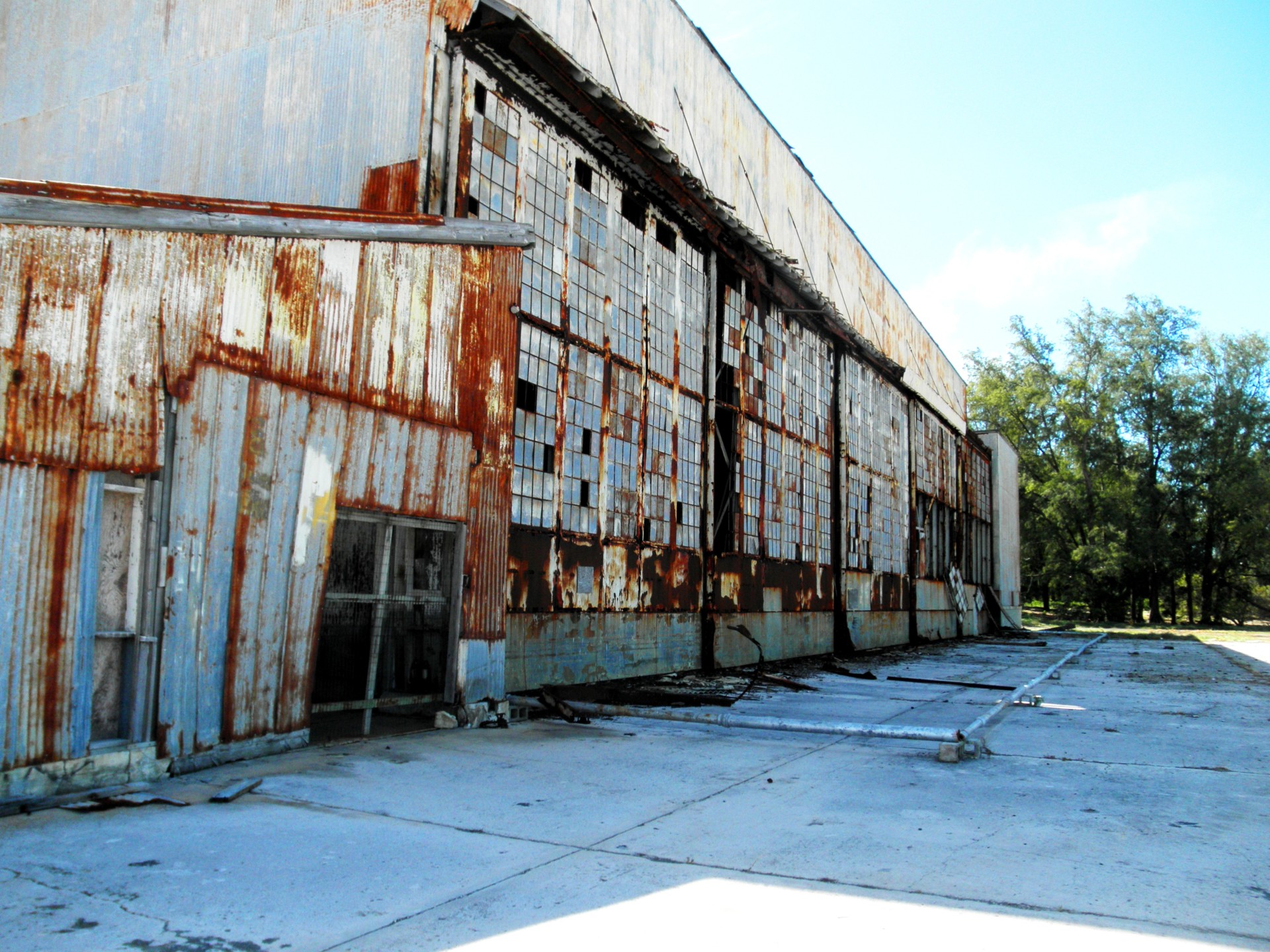
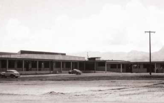
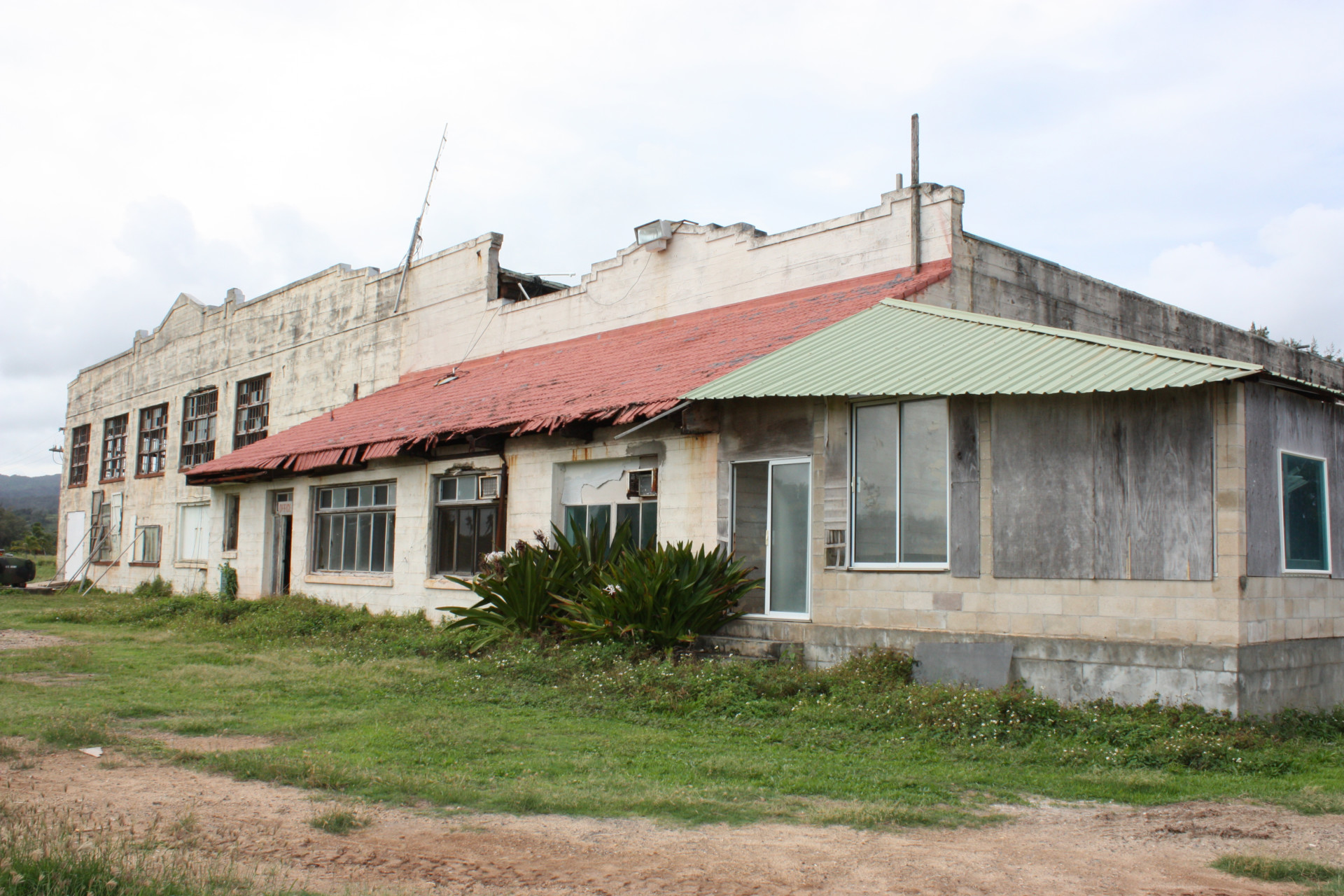
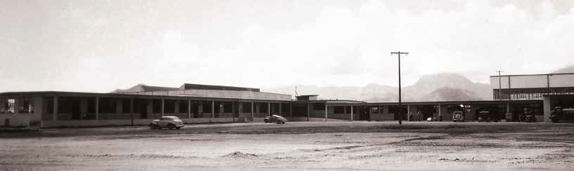
Photos: Courtesy of Rae Huo; Hawaiian Collection, Hamilton Library at UH Manoa UPDATE: 2015 Article Written By: Katrina Valcourt, HONOLULU Magazine Not much has happened with this site, though owner Jeremy Henderson says they’ve done some minor cleanup to improve the view, secured the buildings for safety reasons and gotten the station onto both state and national historic registers (Marconi Nomination). “We’d still like to preserve the historic buildings,” Henderson says. “Next, we’re planning a market feasibility study” to determine the options for adaptive reuse. Listed as Endangered in 2012 Article Written By: Kathryn Drury Wagner, HONOLULU Magazine What is it? On an oceanfront parcel of land in Kahuku, tucked between Turtle Bay’s golf course and shrimp farms, the Marconi Wireless Telegraph Station gives us a rare glimpse into telecommunications history. The station’s name refers to Guglielmo Marconi, who invited and commercialized a way to transmit Morse signals wirelessly across great distances. Hawai’i was at the forefront in the use of this technology, and when the Kahuku station was built in 1914, it was the largest wireless telegraph station in the world in terms of capacity and power. By 1916, there was regular telegraphic communications between Hawai’i and Japan, a distance of 4,200 miles. The property was purchased by Marconi Point LLC in 2005, says owner Jeremy Henderson. It’s one of only two remaining telegraph stations in Hawai’i (the Koko Head station’s hotel building became Lunalilo’s Home in 1928), and one of only a handful in the country. Receiving stations in Marshall, Calif., and Belmar, N.J., also remain standing. What threatens it? Telegraph declined after Hawai’i was linked to the Mainland by undersea telephone cable in 1957 and, today, the buildings at Marconi station sit vacant and in disrepair. Until Henderson can come up with the right [...]

2016-11-17T11:07:08-10:00November 1st, 2015|Categories: MES Oahu|Tags: , |

Ō’paekaʻa and Pu’uopae Bridges (2012)

UPDATE: 2015 Article Written By: Katrina Valcourt, HONOLULU Magazine Both bridges are scheduled for replacement, with construction beginning on the Pu‘uopae Bridge in January 2017. Instead of steel girders, which have heavily corroded over the years, the new bridge will have concrete beams and a concrete deck, says Kaua‘i County engineer Larry Dill. After its completion, construction will start on ‘Ōpaeka‘a. “The original ‘Ōpaeka‘a Bridge is an iron truss, with the deck mounted at the bottom of the trusses,” Dill says. “It was rehabilitated in 2009 so that the truss no longer supports the bridge, but remains as a visual element. The proposed replacement bridge would have concrete beams and a concrete deck, and the truss would be restored as part of that project, to maintain the appearance of the original bridge.” Listed as Endangered in: 2012 Article Written By: Kathryn Drury Wagner, HONOLULU Magazine What are they? These one-lane, country bridges have different designs, but both serve as some of the few manmade reminders left of the pre-1920s homestead-lands movements on Kaua’i. “We know about Hawaiian culture, and about sugar plantation culture,” says Pat Griffin, a historian and community-preservation advocate, but little about this era, when, “after Hawai’I became a territory, there was a homesteading movement. It was an Americanizing technique, the idea that, if farmers had some parcels of land, it would make it stronger as a territory, and it also gave Hawaiians land.” The O’paeka’a Bridge is also the only known British-made iron bridge in the U.S., and one of only a few surviving iron bridges in the state. It was built in 1888 over the Wailua River, and a section was recycled in 1919 for use at the O’paeka’a stream. Pu’uopae Bridge is in its original, 1915 location, crossing Kalama Stream. What threatens them? Though safe, the bridges are largely constructed of steel and have [...]

2016-11-17T11:40:02-10:00November 1st, 2015|Categories: MES Kauai|Tags: , |

Midway Atoll Seaplane Hangar (2012)

Photos: Courtesy of U.S. Fish And Wildlife Service Article Written By: Kathryn Drury Wagner, HONOLULU Magazine What is it? A massive, steel-frame seaplane hangar, this 1941 building was designed by Albert Kahn, a renowned architect of industrial spaces. The hangar was one of the first buildings constructed for the U.S. Naval base at Midway Atoll, and was impressive not only for its size, but also for its use of glass and light. The hangar was bombed during the Japanese attack on Midway Atoll on Dec. 7, 1941, rebuilt, and then bombed again on June 4, 1942, during the Battle of Midway. The Navy rebuilt it again, though at half the size of the original building. “It's the iconic building of the time, of the battle,” says Barry Stieglitz, project leader, Hawaiian and Pacific Islands, for the U.S. Fish and Wildlife Service, which oversees the area. Standing near the hangar, he says, it's easy to make the mental shift from seeing millions of albatross that today using Midway Atoll as a breeding ground to imagining a scene of war. “You put yourself in the shoes of those young boys and how completely terrifying it must have been.” What threatens it? The hangar has holes in its roof and inoperable bay doors, which have allowed rain, wind, and salt air to do their worst. Factor in millions of sea-birds, too, as their droppings are caustic. A plan to rehab the building was quite far along – Ferraro and Choi had developed drawings and contractor bids had been sought, but, in 2012, all plans were scrapped due to federal funding shortages. The estimated price tag is more than $20 million, says Stieglitz. “Given its remoteness and lack of [...]

2016-11-17T11:49:18-10:00April 4th, 2014|Categories: MES Northwestern Islands|Tags: , |

Varsity Building (2012)

Article Written By: Kathryn Drury Wagner, HONOLULU Magazine What is it? The five-story Varsity Building was designed by local firm Wimberly and Cook in 1963 to house the First National Bank. It's one of a posse of circular buildings that went up around Oahu in the 1950s and 60s, including the Waikiki Circle Hotel and Waipahu's branch of American Security Bank. Curved buildings are examples of the mid-century Modernism movement, which showcased bold experimentation in shapes and materials, such as concrete, which had not been widely used previously. What threatens it? For the past four years, Kamehameha Schools has been collecting pieces of property in the Mo'ili'ili area, forming a contiguous area slated for redevelopment. The assemblage is complete, says Paul Quintiliani, director of Kamehameha Schools' commercial real estate division. “We have begun to shift our focus towards what makes the most sense.” The overall goal, he says, is to “enhance this part of urban Honolulu by creating a heart for the community that simultaneously improves the gateway into UH Manoa.” He says this will include greater pedestrian connectivity, public spaces, and new dining and entertainment options. KS is still in the planning phases; some of the possible permutations include the varsity building, some do not. What can be done? If you're a fan of Modernism, speak up, as community input will be important. Quintiliani says that architectural historians have been consulted to better understand the context of the Varsity Building, and that KS “does not approach redevelopment with the view that demolition is the approach of first choice.”

2016-11-17T09:32:19-10:00March 3rd, 2014|Categories: MES Oahu|Tags: , |

WWII Era Sites on the Marine Corps Base (2012)

Photos: Courtesy of Marine Corps Base Hawaii Article Written By: Kathryn Drury Wagner, HONOLULU Magazine What is it? The Marine Corps base (MCB) Hawai‘i is home to several hundred historic properties, including three on the 2012 list. They include the Bachelor Enlisted Quarters buildings, built in 1940, and a Marine Air Group Headquarters Building, constructed in 1941. There is also World War II damage to some of the base’s taxiways: bomb craters and possible strafing marks that are apparent damage from the Dec. 7, 1941, attack. The two bomb craters are large, 7 to 11 feet in diameter, says MCB Hawai‘i’s June Cleghorn, senior cultural resources manager in the Environmental Compliance and Protection Department, while smaller pockmarks probably came from the bullets. The holes have been filled with concrete, but the outlines of their original shapes and locations are visible. What threatens them? Base Hawai‘i is expanding, welcoming up two squadrons of MV-22 Osprey aircraft and one Marine Light Attack Helicopter squadron, starting in 2012 and continuing into 2018. Along with the space needed for the aircraft, the base will also need to reconfigure for 2,128 more personnel and dependents. According to Cleghorn, demolition is planned for no more than six of the 11 total World-War-II-era BEQs and the MAG building. Resurfacing of the taxiways is also planned. What can be done? After a two-year review process involving more than 40 consulting parties, the BEQs and MAG building demolitions sound like a done deal.(Though it may not console World-War-II history buffs, the new barracks construction will feature LEED certification standards, including sustainable site development and water and energy efficiency.) The bomb and bullet marks on the ground may be saved. Cleghorn says the Corps recognizes their [...]

2017-04-21T01:01:42-10:00March 3rd, 2014|Categories: MES Oahu|Tags: , |

Hanalei Pier Canopy (2012) SAVED

UPDATE: SAVED IN 2013 The rebuilt canopy at the end of Hanalei Pier recently reopened after a reconstruction project was completed by the Rotary Club of Hanalei Bay. Prior to the reconstruction effort, which began in March and concluded in May, the canopy suffered from dry rot and cracked beams, holes in the roof and broken support struts. The State Department of Land & Natural Resources, Kaua’i Division of Boating and Ocean Recreation planned to demolish the structure, prompting HHF to declare it an Endangered Historic Place. The Rotary Club of Hanalei Bay established a “Save the Pier” project involving the community, the State of Hawai‘i, and the County of Kaua‘i to preserve the historic and community landmark. Members worked with the state’s Department of Land and Natural Resources on reconstruction plans while raising money to restore what has become a symbol of Hanalei Bay. Rotary Club raised more than $188,000 to rebuild and provide upkeep to the community icon. Originally constructed of wood, the Hanalei Pier has been in existence since 1892. In the early 20th century, the pier was a major hub for the transportation of rice, sugar and various goods between the other Hawaiian Islands and the rest of the world via the Pacific Ocean. It became a recreational resource in the last 80 years when shipping halted and is a popular venue for fishing, picnics and filming. LISTED AS ENDANGERED IN 2012 Article Written By: Kathryn Drury Wagner What is it? Originally built for rice transportation, this picturesque pier is now valued for recreational use. “It’s a historic part of Hanelei and it’s important to the community for fishing and picnicking,” says Barbara Robeson, a longtime resident and a consultant on preservation [...]

2017-04-21T01:01:46-10:00March 3rd, 2014|Categories: MES Kauai|Tags: , |
Go to Top